
Sea Level Rise Meme Catalogue
Destroy the sea level rise myth in seconds with our ever growing collection of sea level rise memes. From the UK to Australia to the USA to Europe and everywhere in between, see the lack of sea level rise from all angles.
Get new memes and facts in your inbox
No spam. Unsubscribe any time.
Support The Climate Con
We are supported by people like you. Become a member for £2.99 a month, or make a one-off donation, to keep new memes and facts coming.
01 Reine | 02 Ilfracombe | 03 Cliffs of Moher | 04 Clovelly | 05 Miramare Castle | 06 Caernarfon Castle | 07 Whitby | 08 Vlacherna Monastery and Pontikonisi | 09 Castel dell’Ovo | 10 Castello Aragonese | 11 St Michael’s Mount | 12 Fort Denison | 13 Kingswear Castle | 14 Statue of Liberty | 15 Durdle Door | 16 The Green Bridge of Wales | 17 The Needles | 18 Ventnor Beach | 19 Kingsgate Castle
Reine, Lofoten
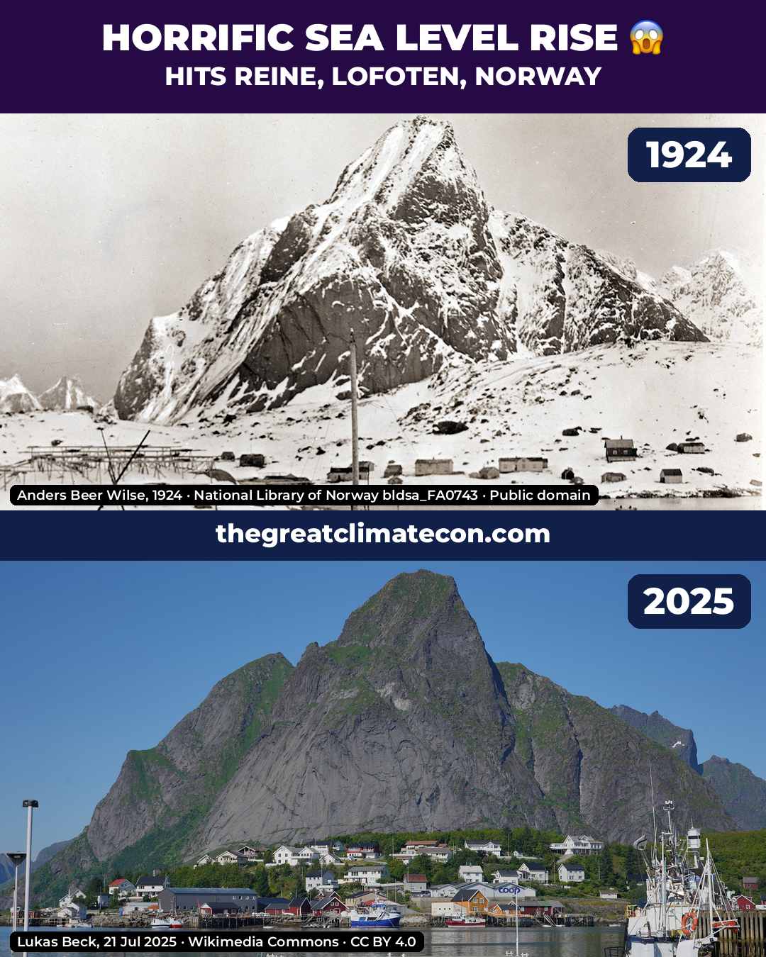
Reine is a fishing village in Moskenes on the Lofoten islands of Norway, sitting at the foot of the mountain Reinebringen. The older photograph is by Anders Beer Wilse, taken in 1924 and held by the National Library of Norway (bldsa_FA0743). It looks across the harbour at the village and the mountain behind: rorbuer and drying racks along the shore, with the water in the foreground at the foot of the settlement.
Lukas Beck photographed the same harbour on 21 July 2025. The village still stands along the same shore at the foot of the same mountain. Boats sit in the harbour in front of the houses; the water has not risen over the village.
Ilfracombe, Devon
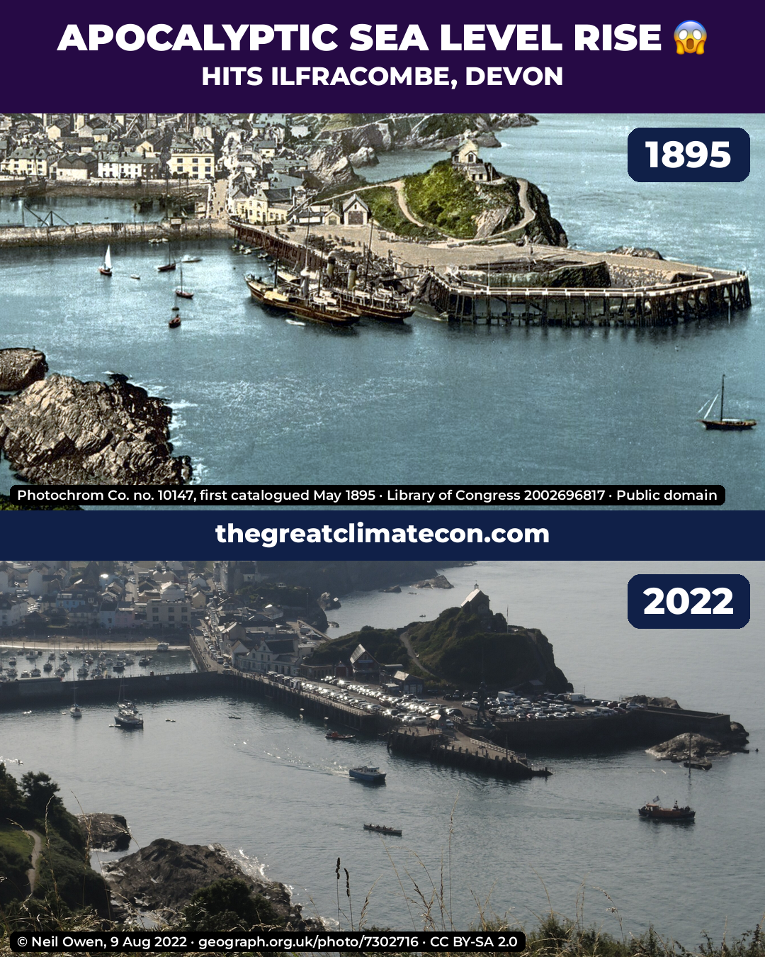
Ilfracombe is a harbour town on the north Devon coast. The older view is a Photoglob Zürich photochrom, print 10147 “From Hillsborough, Ilfracombe”, first catalogued in May 1895. It looks down from Hillsborough at the harbour: the chapel on Lantern Hill, the pier and outer wall, fishing boats at the quay, and the town climbing behind. The harbour is full, with the water at the quay and the outer wall.
Neil Owen photographed the same harbour from Hillsborough on 9 August 2022. The chapel still stands on the same headland, the pier is still there (now with cars on it), and boats still sit in the basin. The water still fills the harbour at the same walls. The town has not gone under.
Cliffs of Moher, County Clare
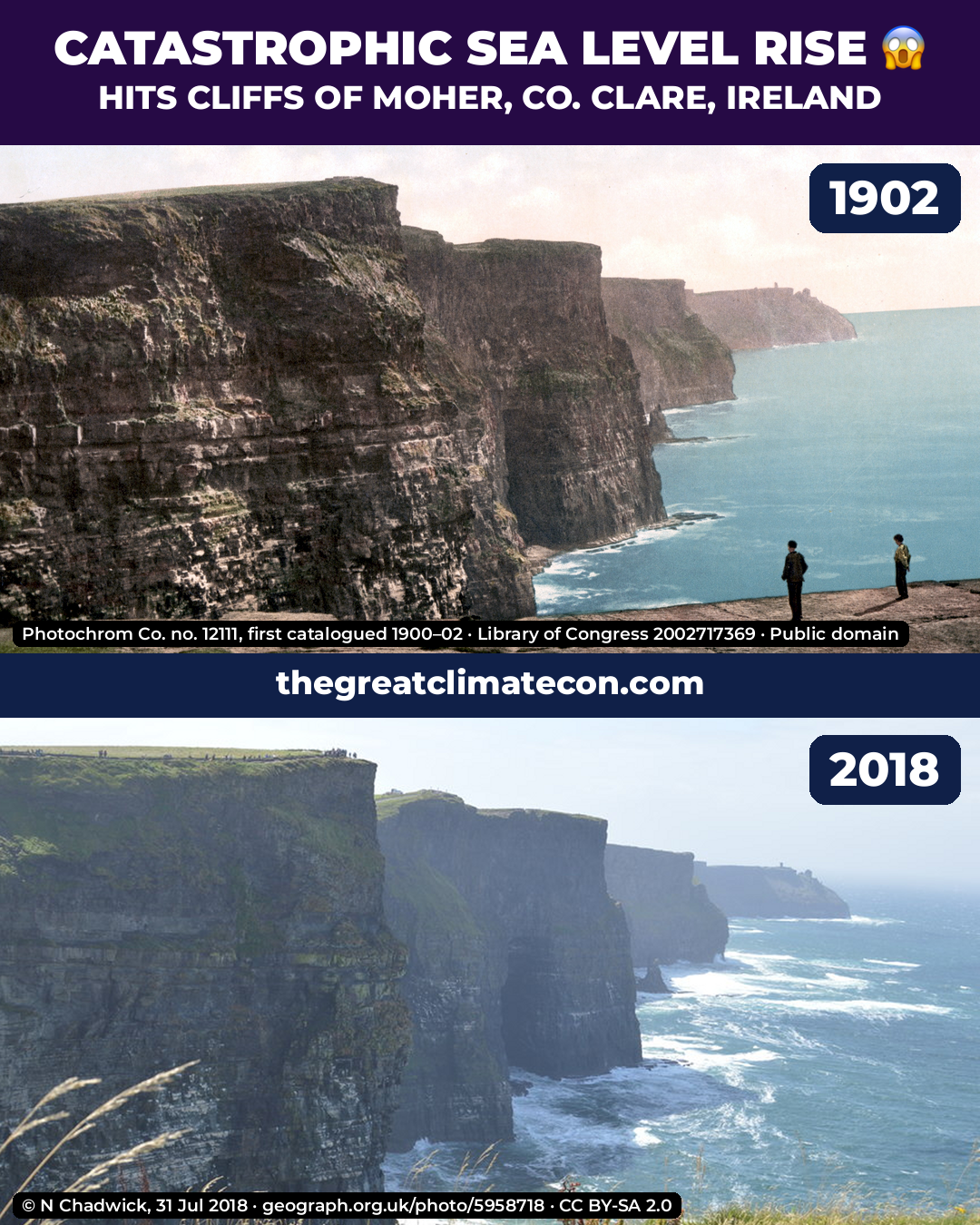
The Cliffs of Moher are sea cliffs on the Atlantic coast of County Clare, Ireland. The older view is a Photoglob Zürich photochrom, print 12111, first catalogued in 1900–02 (the meme uses 1902). It looks along the cliff line toward O’Brien’s Tower on the distant headland, with two figures standing on the cliff edge in the foreground and the sea at the foot of the cliffs.
N Chadwick photographed the same stretch on 31 July 2018. The cliffs still drop to the same sea, and O’Brien’s Tower still stands on the headland. The cliffs have not gone under.
Clovelly, Devon
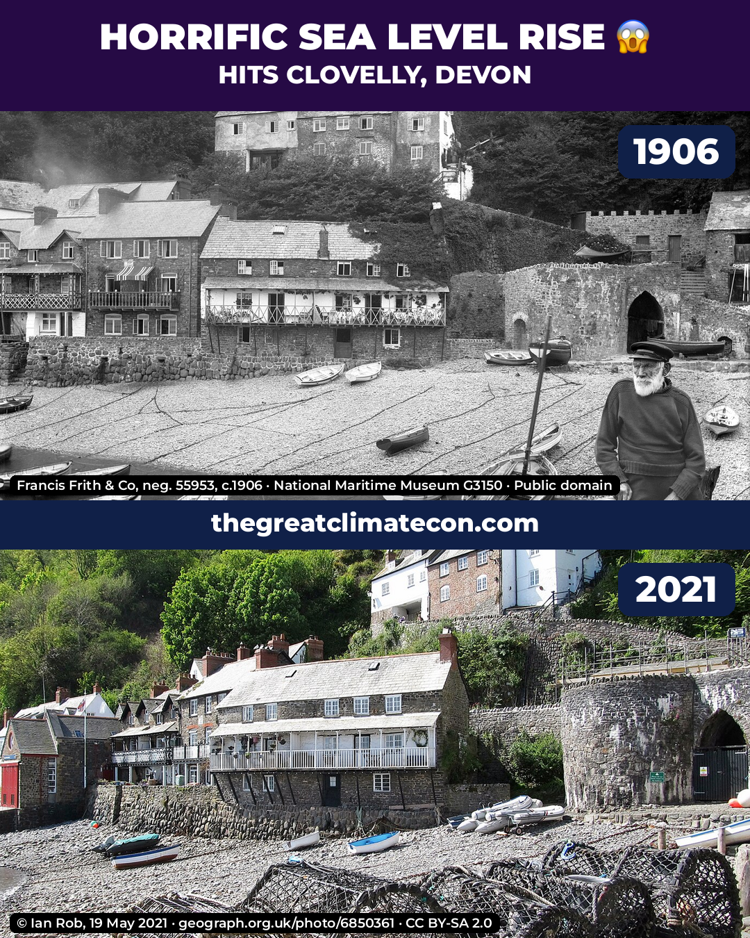
Clovelly is a steep village on the north Devon coast, with a pebble harbour at the foot of the street. The older photograph is by Francis Frith & Co, negative 55953, about 1906, held by the National Maritime Museum (G03150). It looks across the harbour beach at the waterfront houses and the stone harbour wall and arch on the right. Boats rest on the pebbles, and the houses stand dry above the beach.
Ian Rob photographed the same harbour on 19 May 2021. The same houses and harbour wall are still there, with boats and pots on the same pebble beach. The water has not risen over the village.
Miramare Castle, Trieste
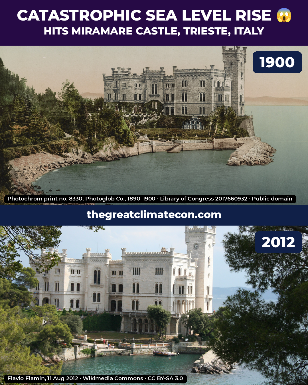
Miramare Castle stands on a rocky promontory on the Gulf of Trieste. The older view is a Photoglob Zürich photochrom, print 8330 “Miramar. Da Settentrione”, dated 1890–1900 (the meme uses 1900). It shows the castle above a small cove, with a stone terrace around the water and the sea filling that cove at the foot of the terrace.
Flavio Fiamin photographed the same seaward face on 11 August 2012. The castle still stands on the same rock, and the water still sits in the cove at the stone terrace around its base. The castle has not gone under.
Caernarfon Castle, Wales
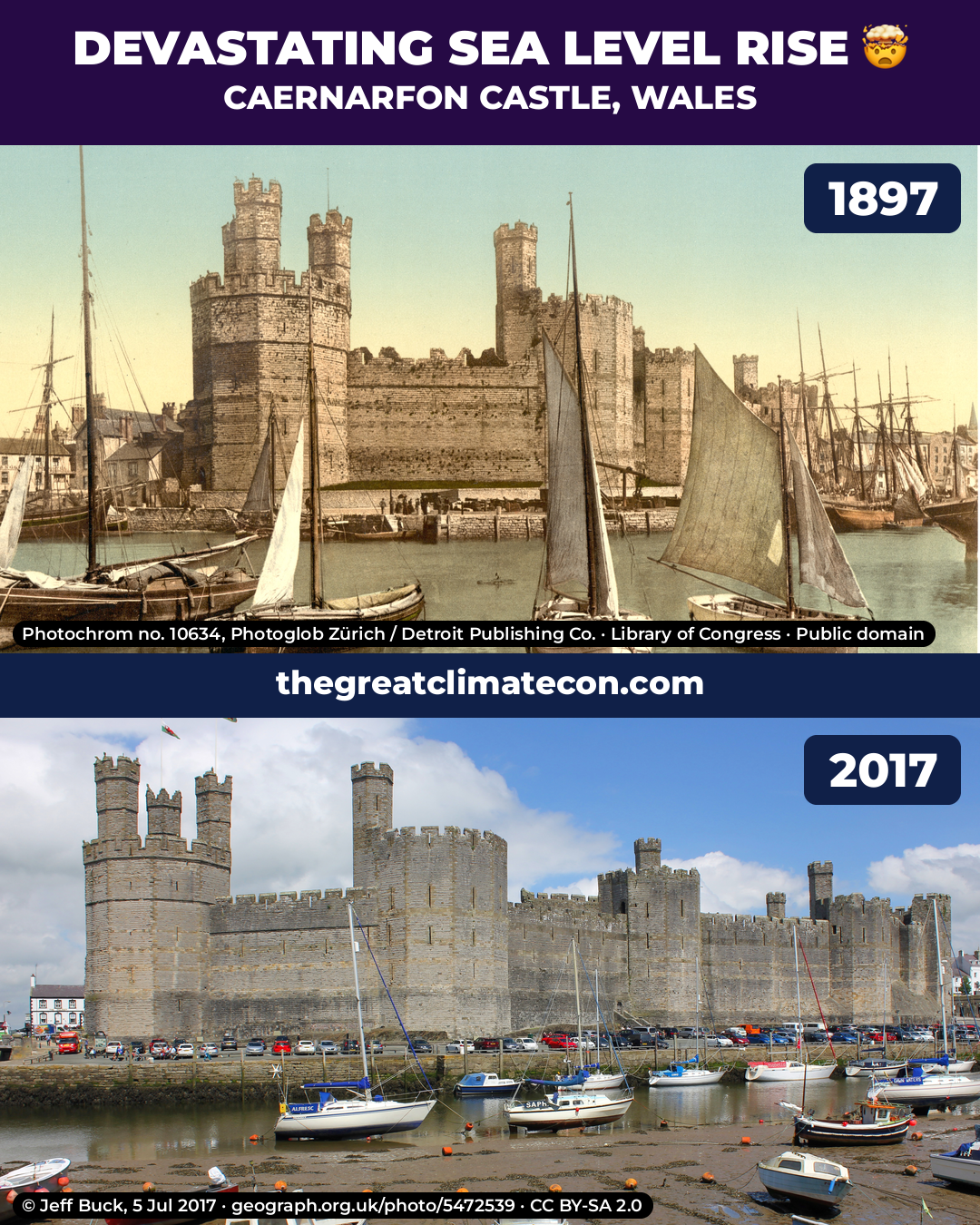
Caernarfon Castle stands on the Afon Seiont in north Wales. Building began in 1283 under Edward I; the Eagle Tower and the curtain walls along the river were finished by about 1330. The older view is a Photoglob Zürich photochrom, print 10634, dated 1897. It is taken from the south bank of the harbour looking north-north-east at the castle’s south front: the three-turreted Eagle Tower on the left, the curtain wall, and the Queen’s Tower. The harbour is brim-full, with sailing boats floating in front of the walls.
Jeff Buck photographed the same front on 5 July 2017. The same towers still stand in the same order. The water has dropped to a narrow channel, the quay wall is exposed down to its weedy base, and boats sit on the harbour mud. After 120 years the castle is still dry, and the harbour holds less water than in 1897, not more.
Whitby, North Yorkshire
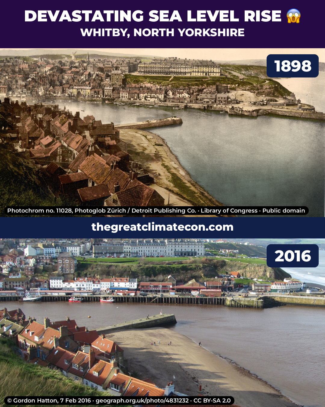
Whitby stands on the River Esk where it meets the North Sea. The older view is a Photoglob Zürich photochrom, print 11028 “Whitby, from East Cliff”, dated 1898. It looks west from the East Cliff above the red-roofed cottages: Tate Hill Pier in the middle, Tate Hill Sands curving below, and the West Cliff and West Pier beyond. The water comes well up the sands, leaving only a narrow strip under the cottages.
Gordon Hatton photographed the same view on 7 February 2016. Tate Hill Pier and the West Cliff are still in the same places. The sands are now a wide beach with people walking on them, and the water’s edge has pulled back toward the channel. More shore is visible in the newer picture, not less.
Vlacherna Monastery and Pontikonisi, Corfu
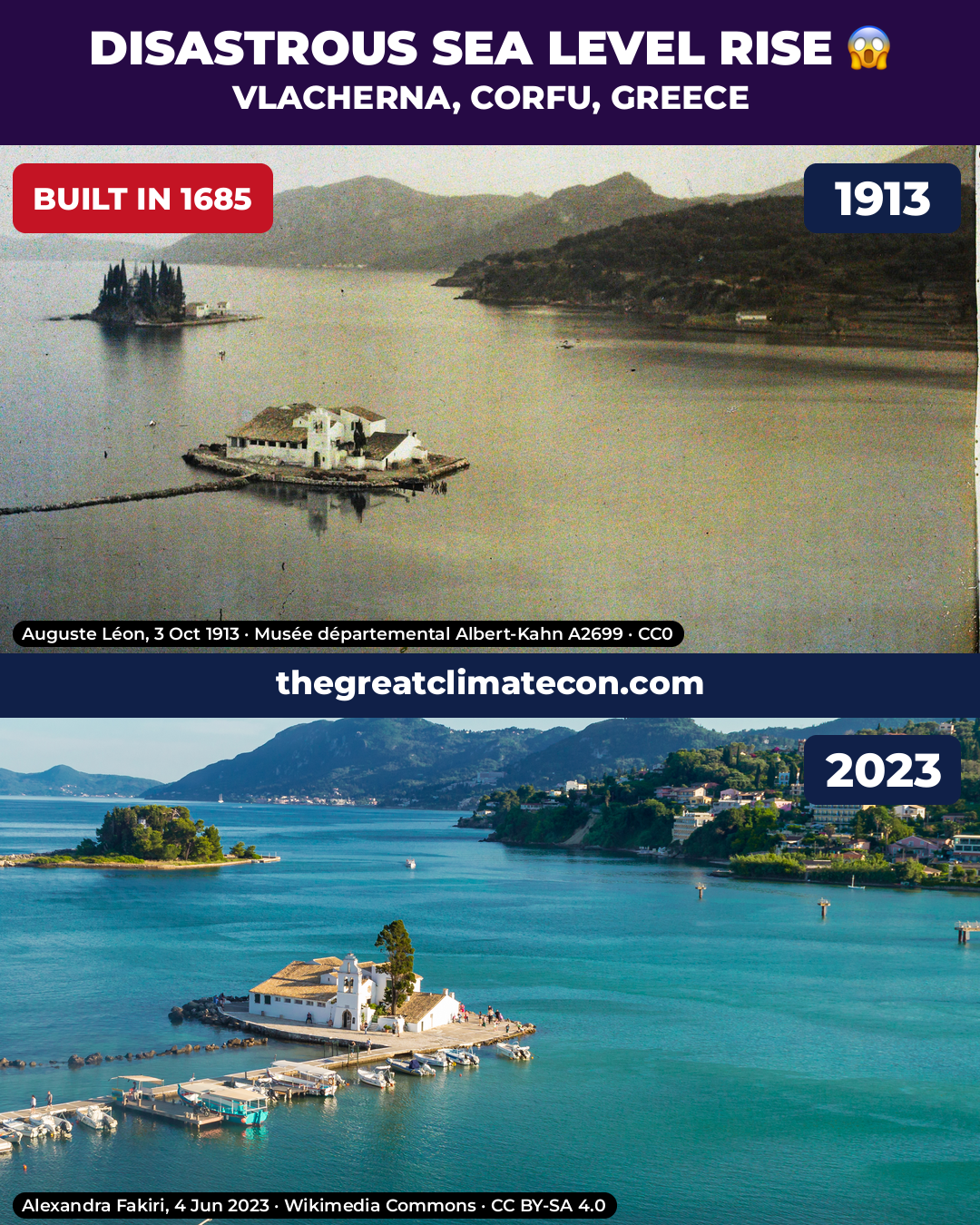
The church of Panagia of Vlacherna stands on a small islet off Kanoni, Corfu. An on-site plaque says the present church was built in 1685. Auguste Léon’s autochrome of 3 October 1913 looks south-east from Kanoni hill: Vlacherna at lower left, the old stone causeway just breaking a flat, calm surface, and Pontikonisi (Mouse Island) behind.
Alexandra Fakiri photographed the same view on 4 June 2023. The old causeway stones still break the surface beside the later concrete walkway, and the sea still meets the same rock rim of the islet. The Ionian tide range here is very small, so the match is not a trick of a low tide. The new walkway, jetties and rebuilt belfry are later additions and are not used as evidence.
Castel dell’Ovo, Naples
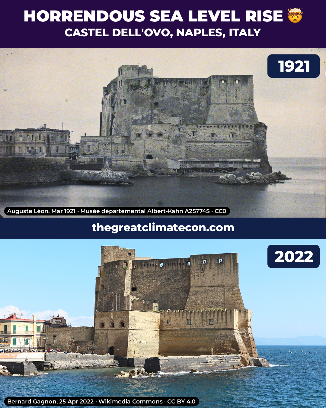
Castel dell’Ovo stands on its islet in the Bay of Naples. The Normans built a castle here in the twelfth century; it was later rebuilt. The older photograph is an autochrome by Auguste Léon, taken in March 1921 from the Via Partenope / Chiatamone shore and looking south-west at the seaward face. The water laps the foot of the walls, and rocks break the surface in front of the castle.
Bernard Gagnon’s photograph of 25 April 2022 shows the same face from a little closer in. The sea still meets the same foot of the walls, and the same rocks still break the surface. A modern stone ledge along the base is later work and is not the comparison. After 101 years, the castle is standing in the same sea.
Castello Aragonese, Ischia
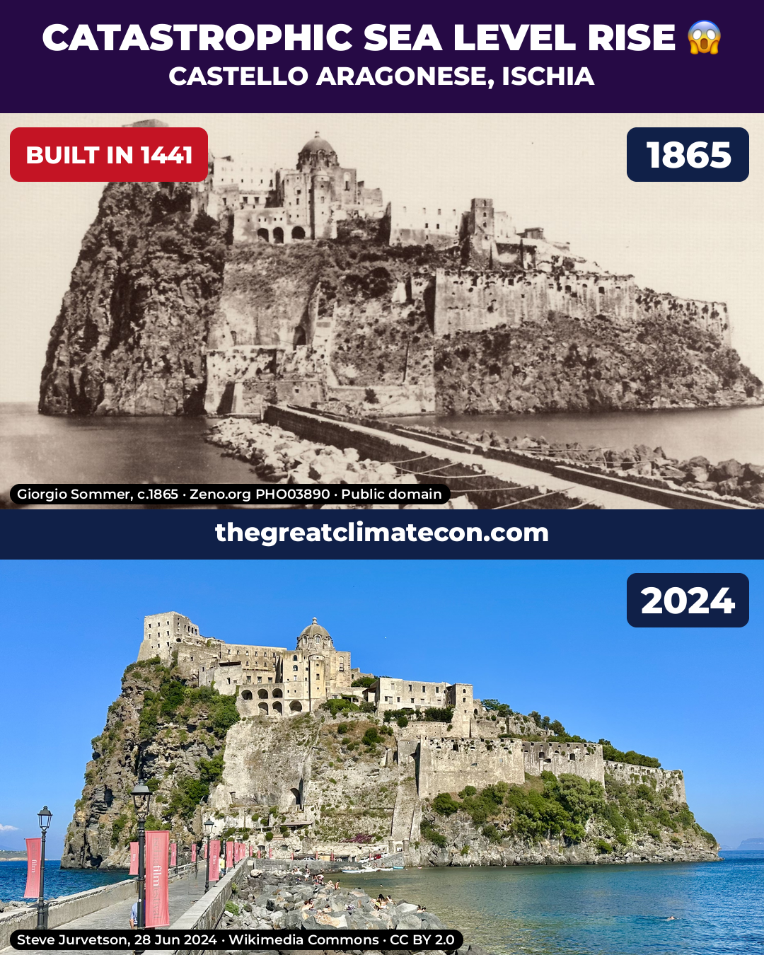
Castello Aragonese stands on its rock off Ischia Ponte. A fort was first built here in 474 BC; Alfonso of Aragon rebuilt the castle and threw a stone bridge across to the island in 1441. Giorgio Sommer photographed it around 1865: the water sits at the foot of the causeway rocks under the castle.
Steve Jurvetson photographed the same rock and causeway on 28 June 2024. The same causeway still runs to the same rock, the water still sits at the foot of those rocks, and people are on them. The castle is still standing in the same sea.
St Michael’s Mount, Cornwall
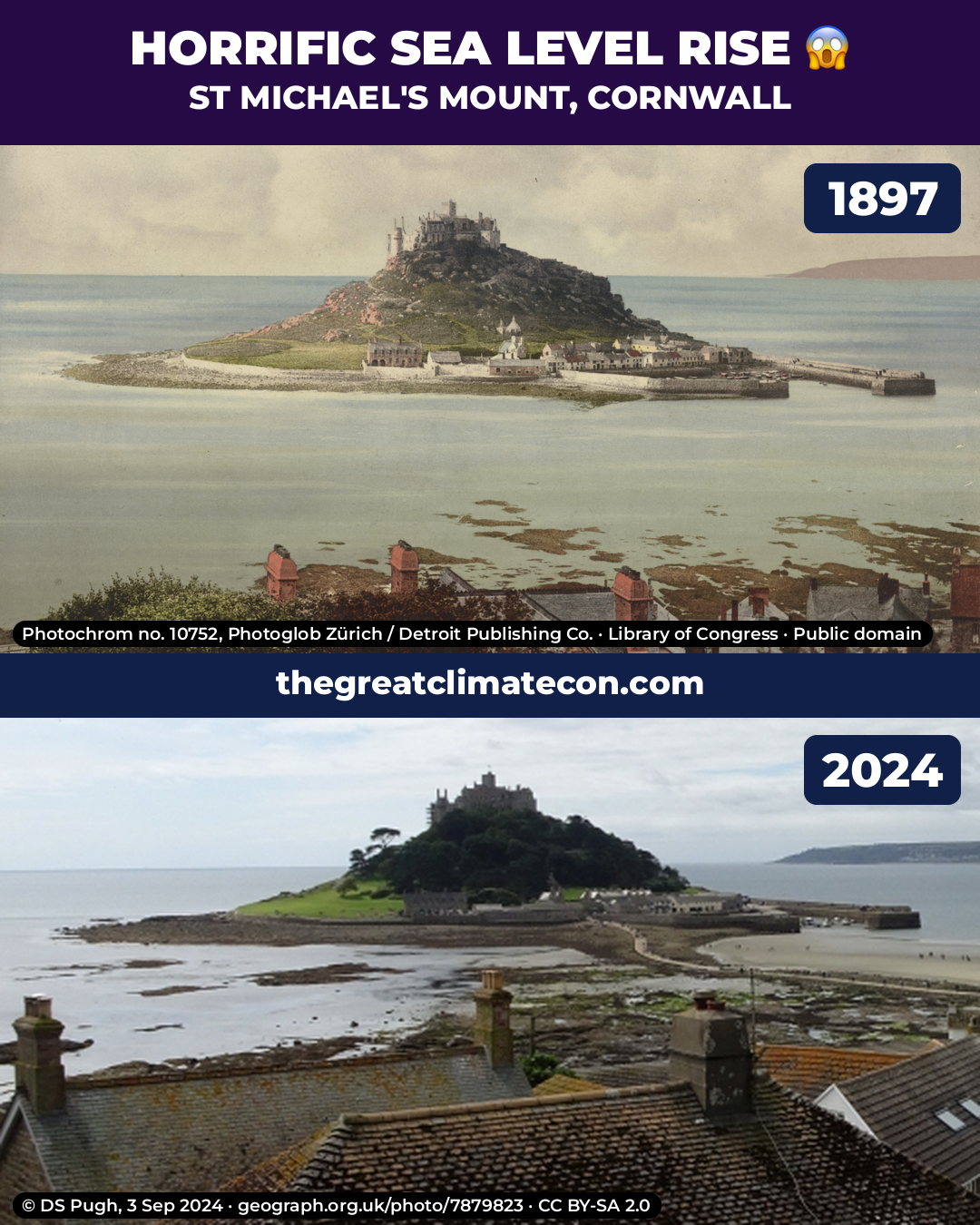
St Michael’s Mount stands in Mount’s Bay off Marazion, Cornwall, with a castle and priory on the summit (the priory was founded about 1135). The older view is a Photoglob Zürich photochrom, print 10752 “Penzance. St. Michael’s Mount”, dated 1897. It is taken from the slope above Marazion looking south-west over the town roofs: the castle on the summit, the village and harbour at the Mount’s foot, and the harbour pier running out to the right. The causeway is completely covered and the bay is full right round the Mount, with only a few weedy rock tops showing.
DS Pugh photographed the same rooftops view on 3 September 2024 from Back Lane in Marazion. The causeway is fully exposed, with a broad stretch of sand and rock between the town and the Mount, and people out on the sands. The castle still stands on the same summit; more of the shore is visible in the newer picture, not less.
Fort Denison, Sydney Harbour
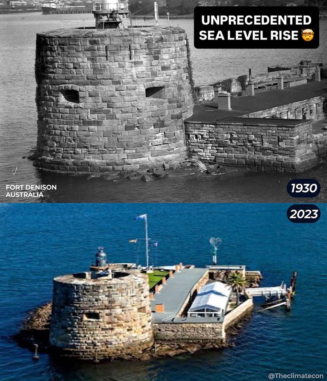
Fort Denison is a stone martello tower and battery on a small rocky island in Sydney Harbour, Australia. The meme dates the photographs 1930 and 2023. The older view is a close shot from the water: the round tower fills the frame, with the sea at the foot of the masonry and rocks at the waterline.
The newer view is from higher up and further back, showing the whole islet. The tower still stands on the same rock, and the water still surrounds the island at the base of the stonework. The fort has not gone under. No photographer or collection credit appears on the meme, and the original source pages have not been verified.
Kingswear Castle, Devon
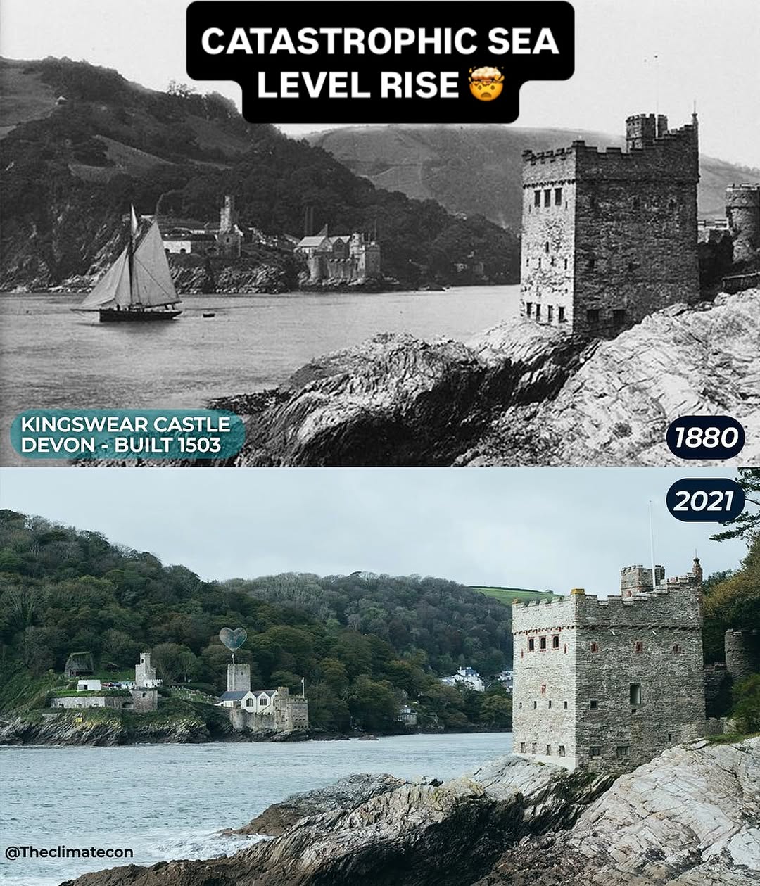
Kingswear Castle is an artillery tower on the east bank of the River Dart, opposite Dartmouth Castle. The meme dates it to 1503, and dates the photographs 1880 and 2021. In the older view the tower stands on the rocks in the right foreground; across the river are Dartmouth Castle and the houses on that bank, with a sailing boat on the water. The river meets the rocky shore at the foot of Kingswear Castle.
The 2021 photograph shows the same pair of castles from a similar angle. The water still meets the same rocks at the foot of Kingswear Castle, and Dartmouth Castle still stands on the opposite bank. No photographer credit appears on the meme, and the original source pages have not been verified.
Statue of Liberty, New York
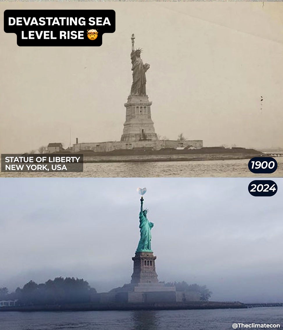
The Statue of Liberty stands on Liberty Island in New York Harbour. It was dedicated in 1886. The meme dates the photographs 1900 and 2024. Both look from the water toward the statue on its island: the pedestal and figure rise well above the shore, and the water surrounds the island rather than covering it.
In the 2024 view the statue still stands on the same island, with the water still around the island’s edge. Trees have grown on the island, but the monument has not gone under. No photographer credit appears on the meme, and the original source pages have not been verified.
Durdle Door, Dorset
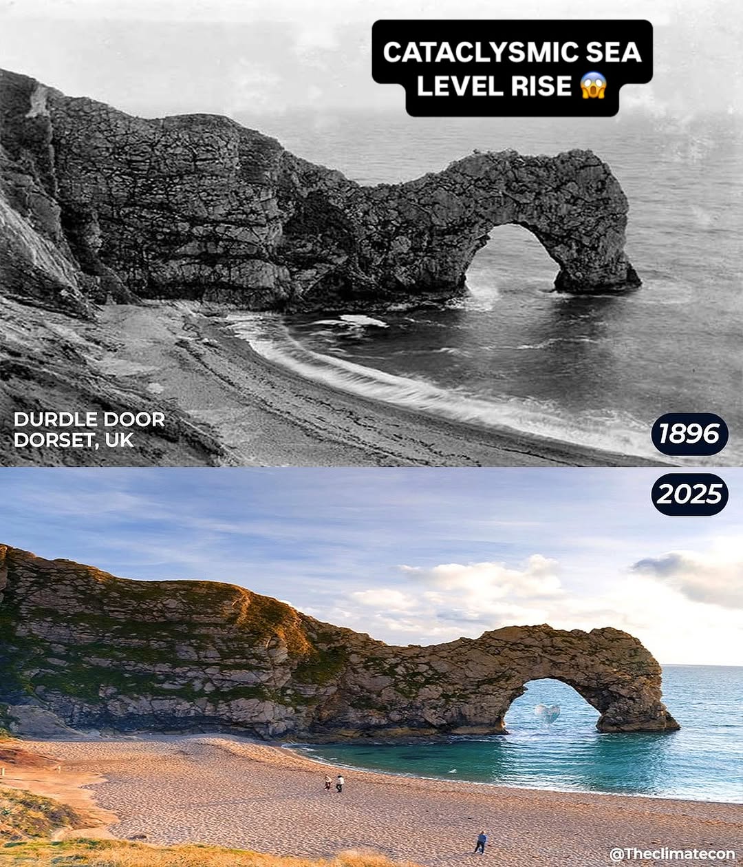
The 2025 view shows the same arch from the beach. The sand is still there, people are walking on it, and the sea still runs through the same arch. The landmark has not gone under. Source pages for these two photographs have not been verified, so no credits are linked.
The Green Bridge of Wales
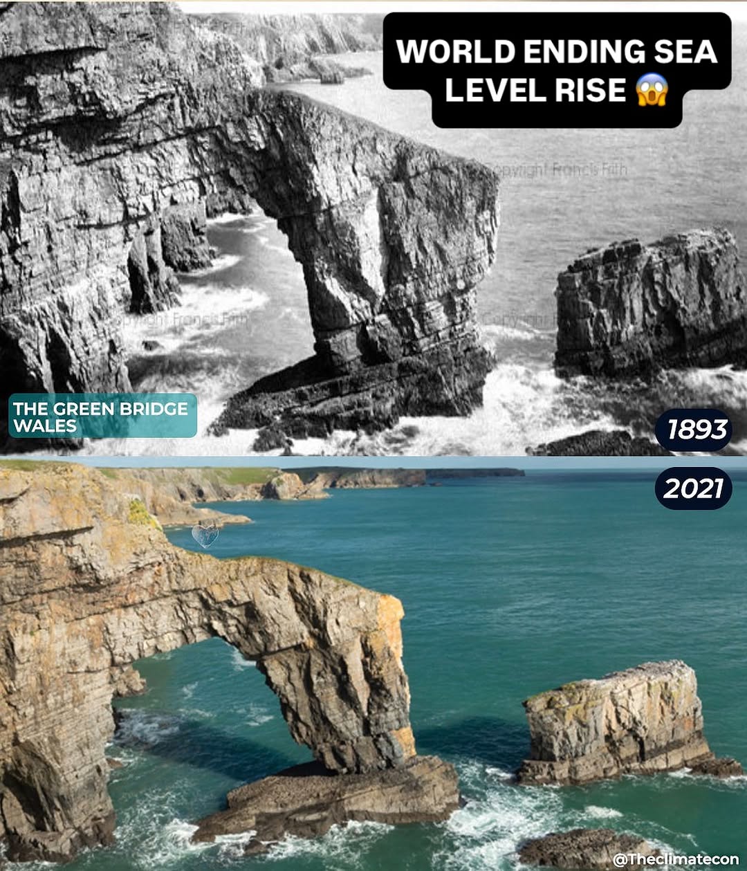
The Green Bridge of Wales is a natural limestone sea arch on the Pembrokeshire coast. The meme dates the photographs 1893 and 2021. The older view, which carries a Francis Frith copyright mark, is a close, low shot of the arch and the detached stack to its right, with waves around their feet.
The 2021 view is from higher up and further back, showing more of the cliff. The same arch and stack still stand in the sea, with water around their bases. A matching source page for the Frith print has not been verified, so the credit is given here without a link; the modern photograph has no credit on the meme.
The Needles, Isle of Wight
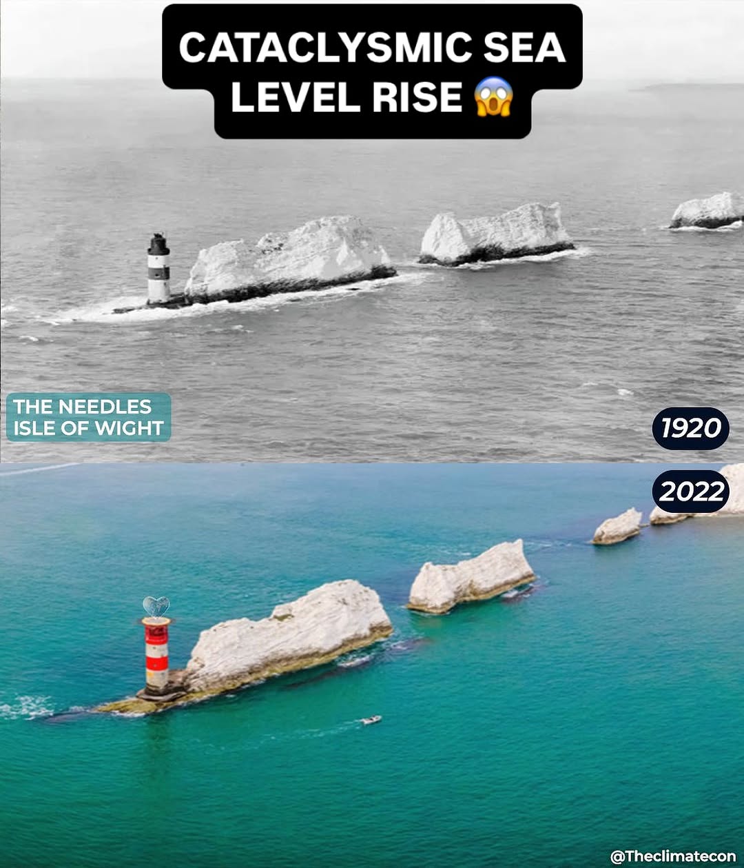
The Needles are the chalk stacks off the western tip of the Isle of Wight, with a lighthouse on the outermost rock. The meme dates the photographs 1920 and 2022. Both look along the line of stacks from the sea: the lighthouse stands on the outer stack to the left, and the water surrounds the feet of the rocks.
In the 2022 view the same stacks and lighthouse are still there. The lighthouse has been repainted (black-and-white in the older picture, red-and-white in the newer one); that is a paint scheme, not a change in the sea. No photographer credit appears on the meme, and the original source pages have not been verified.
Ventnor Beach, Isle of Wight
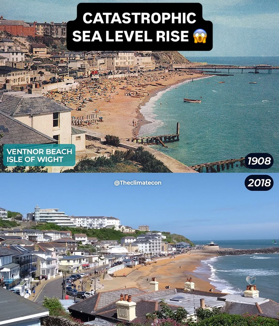
Ventnor is a seaside town on the south coast of the Isle of Wight. The meme dates the photographs 1908 and 2018. The older view looks along a crowded sandy beach toward a pier, with houses climbing the hill and a timber structure in the water in the foreground.
The 2018 view is from a higher rooftop standpoint over the same bay. There is still a sandy beach, the town still stands along the shore, and the old pier is gone, replaced further along by later harbour works. The town has not gone under. Because the camera is higher and the waterfront has been rebuilt, this is not offered as a measured drop. No photographer credit appears on the meme, and the original source pages have not been verified.
Kingsgate Castle, Kent
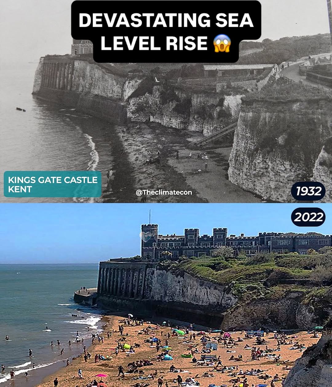
Kingsgate Castle stands on the chalk cliffs above Kingsgate Bay, near Broadstairs in Kent. The meme dates the photographs 1932 and 2022. The older view looks from the bay up at the cliffs, with the castle on the cliff top, a narrow rocky shore at the foot, people on that shore, and steps down the cliff.
The 2022 view shows more of the castle’s full facade above a wide sandy beach crowded with people. The castle still stands on the same cliff, and people are still on the shore at its foot. No photographer credit appears on the meme, and the original source pages have not been verified.